
Description
Save 50% with a Unit Bundle!
Important Notes:
• Download a FREE Unit Bundle to learn more about all my products.
• Save $$$ with the Earth Science Complete Curriculum
• Save $$$$ with the Integrated Science Complete Curriculum
This bundle includes:
• Editable PowerPoint Presentation, Student Notes and Exam
• Printable and Digital Interactive Notebooks with Editable Notes and Quizzes
• Printable, Digital and Editable Bell Ringers Tiered to Bloom’s Taxonomy
• Homework with Standardized Test Prep Questions
• Reading Passages with Questions that support Informational Text ELA CCSS
• SNAPs Lab Stations Activities
• Vocabulary Activity Pack and Word Wall Cards
• Study Guide, Practice Tests, Task Cards and High-Yield Review Sorts
• Differentiated Planning and Pacing Guide
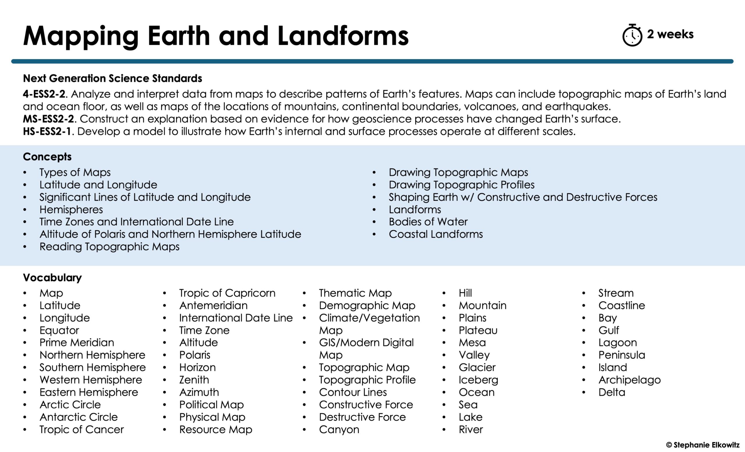
Topics Covered
Topic 1: Types of Maps
Topic 2: Mapping Earth
Topic 3: Time Zones
Topic 4: Finding Latitude with Polaris
Topic 4: Reading Topographic Maps
Topic 5: Creating Topographic Maps
Topic 7: Creating Topographic Profiles
Topic 8: Landforms & Bodies of Water
Topic 9: Coastal Landforms
UNIT GOAL
Students will develop an understanding of how maps and coordinate systems are used to describe and analyze Earth’s surface, including landforms, bodies of water, and coastal features. They will explore how latitude, longitude, time zones, and tools like topographic maps or celestial navigation provide evidence for Earth’s patterns and processes, and apply this knowledge to interpret human and environmental interactions.
Mapping Earth PowerPoint, Notes & Exam
All items in this product are 100% EDITABLE. The product includes a presentation (concepts differentiated), student notes (differentiated scaffolded and modified notes included, a summative examination (differentiated and answer key included) and a standardized-test style examination. A color-shape code is found on the upper left corner of every slide to help you differentiate concepts for your students’ needs and abilities. Google App compatible slides and notes are included. Self-grading digital assessments made with Google Forms included. Google app resources are provided via force-copy links.
Mapping Earth Interactive Notebook Unit
The interactive notebook unit is divided into INB lessons. Each differentiated lesson includes an overview with the LO(s) and NGSS alignment, one page of input notes, at least one INB activity (key included), a 4-5 question mini assessment (key included) and two-part reflection exercise. Editable INB input notes and quizzes are included.
The digital interactive notebook is the counterpart to the printable INB unit. Each lesson includes one page of editable input notes, a digital INB activity and a two-part formative reflection. Digital quizzes made with Google Forms – force-copy links provided.
Mapping Earth Bell Ringers
Differentiated and tiered 3-part activities designed to “warmup” students at the beginning of a lesson. Full and half page printing options. Digital activities as a fillable slides compatible with PowerPoint and Slides included. Editable presentation and key included.
Mapping Earth Homework
Differentiated two-page homework assignments. First page includes 3-part tiered activity with short answer questions. Second page includes standardized test style multiple choice questions. Digital activities as a fillable slides compatible with PowerPoint and Slides included. Key included.
Mapping Earth Reading Passages
Differentiated reading passages with text-based evidence comprehension questions. Each passage is accompanied by a summary of key ideas and vocabulary, five tiered short short answer questions and 10 multiple choice questions aligned with Middle School ELA CCSS RI.1 – RI.10. Immersive Reader compatible documents. Digital activities as a fillable slides compatible with PowerPoint and Slides included. Key included.
IMMERSIVE READER
This resource includes reading passages that can be read to a student with Microsoft’s Immersive Reader. Immersive-Reader compatible passages are read-only word documents accessed in a web browser. Internet access required. Students are provided links to the Immersive Reader compatible passages in the printable and digital versions of each activity.
Immersive Reader is a FREE Microsoft educational tool. You do NOT need a Microsoft account to access this tool in a web browser. Learn more about Immersive Reader HERE.
Immersive Reader can:
• Read the entire passage to a student
• Help pronounce individual words in a passage as a student reads
• Translate the entire passage or individual words in the passage for ESL students
• Change the font, text color and background color for students with visual impairments
Additional Notes
• Written and video instructions for students are included: http://safesha.re/ppk
• Download a FREE unit of Immersive Reader compatible reading passages HERE.
Mapping Earth Vocabulary Activity Pack
This vocabulary activity pack includes EVERYTHING you need to introduce, reinforce, review and master science vocabulary! Crossword puzzles, flashcards, games and quizzes included. Printable, digital and editable components.
Mapping Earth Word Wall Cards
Each card displays a simple illustration, one vocabulary word and a short definition. Half and quarter page printing options. Color and black and white.
Mapping Earth Unit Review & Test Prep
Study guide and practice tests to review all concepts in the unit. Printable and digital study guide – infographic style and fill-in-the-blank. Editable and self-grading Google Form practice tests.
Mapping Earth Task Cards
Differentiated and tiered task card questions to help assess your students on important concepts covered in this science unit. Printable and digital task cards included. Editable answer sheets and key included.
DIGITAL TASK CARDS
Task cards designed to work with Google Forms included. Can be assigned to students with Google Classrooms or shared as a link with your student any way you choose. Self-grading. Digital task card questions and answers are editable. Task card images are NOT editable. Requires internet access.
HIGH-YIELD REVIEW ACTIVITIES
NO-PREP resources to review HIGH-YIELD topics in science! Each activity focuses on a single topic to develop mastery of that topic. Printable and digital activities and self-grading Google Forms included. This bundle includes three high-yield review activities:
• Latitude and Longitude Review
• Topographic Maps Review
• Landforms Review
Mapping Earth Lab Stations Activities
SNAPs Lab Stations are lab activities that require students to use science, math, literacy, problem-solving and engineering skills. The labs are designed to enhance students’ understanding of scientific concepts and help students apply scientific ideas to the real world. This bundle includes three labs:
• Latitude and Longitude Lab Stations Activity
• Topographic Maps Lab Stations Activity
• Landforms Lab Stations Activity
DIGITAL LAB ACTIVITIES
The SNAPs labs in this unit bundle are offered in a digital format (fillable slides compatible with Microsoft PP and Google Slides) to facilitate distance learning and support digital classrooms. To better support digital classrooms, the assessment station is offered as an editable, self-grading Google Form as well.
DISTANCE LEARNING COMPATIBILITY
SNAPs lab activities are rated for their ease with distance – independent learning. Refer to the Master Lab Skills List for a brief overview of how well each laboratory works in a fully digital classroom and with distance learning.
EDITABLE DOCUMENTS
This download includes an editable word document (docx file) of all lab components:
• Pre-Lab and Post-Lab Activities
• The Lab Overview
• Lab Station Activities and Questions
• Directed Synthesis Project (when applicable)
Important Notes:
• Diagrams, illustrations, tables and graphs essential to lab activities are included
• Illustrative clipart is NOT included
• Editable documents and rubrics are included with the FREE SNAPs Setup Guide
Mapping Earth Unit Planning Guide
This product includes DIFFERENTIATED and EDITABLE documents to help you plan and pace the unit. Suggestions for how to use resources and create lesson plans included.
Next Generation Science Standards
This unit bundle supports NGSS 4-ESS2-2, MS-ESS2-2 and HS-ESS2-1.
TERMS OF USE
• All rights reserved by Stephanie Elkowitz.
• This product is to be used by the original purchaser only.
• Intended for classroom and personal use only.
• Copying for more than one teacher, classroom, department, school, or school system is prohibited.
• This product may not be distributed or displayed digitally for public view.
• Failure to comply is a copyright infringement and a violation of the Digital Millennium Copyright Act (DMCA).